显示标签为“hills”的博文。显示所有博文

2013年8月2日星期五

Ganden Monastery is located on Wangbur Mountain

Ganden Monastery is located on Wangbur Mountain, on the southern bank of Lhasa River in Tagtse County, 47 kilometers (29 miles) from Lhasa City. It stands at an altitude of 3,800 meters (12,467 feet) above sea level! It is one of the earliest and largest Buddhist monasteries in Tibet, and stands atop of the six famous temples of Gelugpa - a branch of Tibetan Buddhism. Its significance as a religious, artistic, political and cultural relic led to it being preserved by the National Key Cultural Relic Preservation scheme in 1961, and is now known as being one of the 'Three Great Temples', together with the Sera Monastery and the Drepung Monastery . Every year, one of the grandest of Buddhist activities - Buddha Painting Unfolding Festival - is conducted here, attracting thousands of visitors and disciples.

 575

The main temple and over seventy buildings were completed that year, 1409, in strict adherence with the Indian monastic rules. The next year, on a hill behind Ganden, Tsongkhapa unearthed the treasure conch shell that Maudgalyayana had buried there. All the prophesies about Ganden Monastery were thus fulfilled. In 1416, Tsongkhapa gave the Ganden conch to his disciple, Jamyang Chojey ('Jam-dbyangs Chos-rje bKra-shis dpal-ldan) (1379-1449), who founded Drepung Monastery ('Bras-spungs dGon-pa) later that year. The conch has been kept at Drepung ever since. Another close disciple, Jamchen Chojey (Byams-chen Chos-rje Shakya ye-shes) (1354-1435), founded Sera Monastery (Se-ra dGon-pa) in 1419, the year Tsongkhapa passed away.

576
Ganden Monastery is comprised of two colleges, Jangtsey (Byang-rtse Grva-tshang) and Shartsey (Shar-rtse grva-tshang), meaning North Peak and East Peak respectively. According to one tradition, they were named after their location to the north and east of Ganden's main temple.
The Ganden Monastery Colleges Jangtse and Shartse have also been reestablished in India. They are named The Ganden Jangtse College and The Gaden Shartse Monastery. They are located in Karnataka. The three main sights in the Ganden Monastery are the Serdung, which contains the tomb of Tsongkhapa, the Tsokchen Assembly Hall and the Ngam Cho Khang the chapel where Tsongkhapa traditionally taught. The monastery houses artifacts which belonged to Tsongkhapa.

2013年6月17日星期一

The Ruins of Guge in Tibet

The Ruins of Guge Kingdom is located on a mountain in Zhabran Village,18km west of the county town of Zhada, 310km south of Shiquanhe Town.
The Guge Kingdom was founded in about the 10th century by a descendant of King Glang Darma, who fled from Lhasa after the collapse of the Tupo Kingdom. The kingdom played an important role in the second renascence in Tibet and survived for about 700 years before disappearing mysteriously in the 17th century.

569
"Guge" is a miracle. For years it strongly attracted numerous explorers, scholars, artists and journalists who traveled from afar to investigate and search for treasures. According to historical records, after the last king of the Tubo Dynasty, Lang Darma, died, the royal family began to fight for the throne. Gyide Nyimagun, Long Darma's descendent, lost the war and ran away to Ngari, where he established a small kingdom. Later, Gyide Nyimagun divided Ngari into three parts and gave them to his three sons. The Guge Kingdom was ruled by Dezogun, Gyide Nyimagun's third son. His regime ran for more than 700 years before being destroyed in a war. According to the Annals of Kings and Officials in Tibet, a total of 16 kings ruled the Guge Kingdom, and Guge Castle was accomplished through constant construction between the 10th and 16th century. Guge has a very significant position in the history of economic and cultural development of Tibet. Many significant Buddhist doctrines of ancient India were passed on to hinterland Tibet via Guge.Guge was also one of the important commercial ports linking ancient Tibet with the outside world.After the Tubo Dynasty died out,Tibet entered a 400-some year period of isolation. Guge was always a large and powerful kingdom. Even the dust of time cannot hide its prosperity and past glory.

570

The ruins lie at a hilltop near a river, covering 180,000 square meters. Houses, cave dwellings, monasteries and stupas are distributed on the hill and surrounding area. Palaces sat on the summit while monasteries on mountainside, cave dwellings for common people at the foot of the hill. The kingdom was enclosed in tunnels and walls with fortifications. Some structures survive time and remain in good condition in this untraversed region though many of them were reduced into dust. A 2 kilometers (1.2 miles) long water tunnel built with stones, in ruins, still dives from the summit into the river below, which used to be water supply of Guge people.

2013年6月4日星期二

Zhada stand the famous Tuolin Monastery and relic Guge Kingdom

Covering an area of 2,464 square kilometers, located in the Zanda County of Ngari Prefecture, Zanda Clay Forest,aka Zanda Clay Forest is the largest clay forest that was formed over one million years ago.

 
Zhada, whose Tibetan meaning is "the place where there are grass in the lower reaches of river", is a County under the govern of Nagri Prefecture. In this county stand the famous Tuolin Monastery and relic Guge Kingdom. As soon as you step into Zhada County, you can see the clay forest towering along both sides of five-kilometer-Elephant Spring River. These clay forest are of different shapes. Some like warriors defending the mountain, some like galloping horses, while others like devoted followers standing there quietly.
The best interpretation of the beauty of the scenery of Zanda, forest soil ditch.

566
Into the forest soil trenches, the people will be the eye as a vast sea forest soil the world shock and awe: the towering forest soil in the hot sun resembles a castles and towers, with one of the vast scene scorch .100 million years ago Zhada forest is more than 500 km wide and the Great Lakes Himalayan orogeny make the surface of the water to sink, the original lake basin in the Loess over many years by the wind and rain erosion and scour, eventually forming a sculpture of this magnificent natural forest soil. forest soil today under intensive folds and ravines, as long as the next torrential rains, it stretches over 30 kilometers of forest soil ditch immediately turned into a 'river' Zada county 'moat'.

2013年5月6日星期一

Naimona'nyi Peak is located at western section of Himalayas

Naimona'nyi Peak is located at western section of Himalayas. It faces Mt. Kailash at a distance. It is praised as the Goddess Mountain by local Tibetans. Tourists planning a Tibet adventure tour to Mt. Kailash would have the chance to witness the charming peak.

552
Naimona'nyi Peak has an area of 200 square kilometers and has 6 mountain ridges, on which are tens of mountains soaring to 6,000 meters. The western ridges fan out from north to south. The only ridge in the east has been corroded into a blade-shape ridge, which is very steep with a height difference of 2,000 meters. Compared with the eastern ridge, the western one has a less steep gradient. Five huge glaciers pour down in the canyon, among which are ice steeps full of cracks.

553
Naimona’nyi peak, Tibetan called “Our Lady” or “Goddess”, located in Champlain County, 7694 meters high, is one of the main peak of the Himalayas. On the next to Manasarovar Lake, separated from the lake north of Mount Kailash distant relative. Naimona’nyi peak radius of about 200 square kilometers, there are six ridges. Ridge line several 10 the hills above 6000 meters, the level of scattered. Fan of the west ridge, arranged from north to south, only east of the ridge has been eroded into the knife ridge, very steep, forming a height difference of nearly 2000 m cliff. In contrast, the west slope is moderate, with five giant glaciers are pouring in the canyon, the ice covered with ice cracks and ice cliffs. May 26, 1985, on the 28th Sino-Japanese joint team of 13 players for the first time along the northwest slope, Naimona’nyi peak the Zhalong Mary Long Pakistani Glacier successful ascent.

2013年4月17日星期三

The Gyantse Dzong is a medieval citadel situated in Gyantse

The Gyantse Dzong is Gyantse's town fort sitting upon a hill just north of Gyantse town on China-Nepal Hwy. Wherever you are in Gyantse, the Dzong can be seen. However, the fort lies abandoned today and many of its interior walls and buildings are in disrepair.

 541
Gyantse Castle or Gyantse Fortress or Gyantse Dzong is a medieval citadel situated in Gyantse, Xigazê Prefecture in China. It was constructed in 1268 by a Sakyapa sect (one of many Buddhist schools) in the beginning of the Nyang Qu river. This strategic location guarded a Southern pass of the Tsangpo Valley and Lhasa. The entrance to the compound is on the Eastern side. Current citadel was constructed on a site of an older 9th century fortifications constructed by anti- Buddhist king Langdharma. Its name literally means "the peak of victory". Prince Phakpa Pelzangpo (1318- 1370) erected a Grand Palace Gyantse in 1365 and his son Kungpa Phakpa (1357- 1412) added new fortification walls. Gyantse Castle harbors an "anti- British" museum devoted to British invasion of 1903- 04.

542
The fort is partly ruined, but there are still some things to see. There is an interesting Anti-British Imperialists Museum here displaying a version of the facts of the 1904 British invasion of Tibet and a major battle that took place. The British used massive firepower to defeat a much less powerful Tibetan army here and a part of the fort was blown up during the battle.
The half hour climb up to the fort is well worth it, as the spot offers fantastic vistas of the monastery compound to the north, the town below, and the surrounding valley.  

2013年4月8日星期一

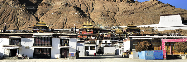
Tashilhunpo Monastery is a historic and culturally important monastery next to Shigatse

  Tashilhunpo Monastery, founded in 1447 by Gendun Drup, the First Dalai Lama, is a historic and culturally important monastery next to Shigatse, the second-largest city in Tibet. It was sacked when the Gurkhas invaded Tibet and captured Shigatse in 1791 before a combined Tibetan and Chinese army drove them back as far as the outskirts of Kathmandu,when they were forced to agree to keep the peace in future, pay tribute every five years, and return what they had looted from Tashilhunpo.


  The monastery is the traditional seat of successive Panchen Lamas, the second highest ranking tulku lineage in the Gelukpa tradition. The "Tashi" or Panchen Lama had temporal power over three small districts, though not over the town of Shigatse itself, which was administered by a dzongpön (prefect) appointed from Lhasa.
  Located on a hill in the center of the city, the full name in Tibetan of the monastery means: "all fortune and happiness gathered here" or "heap of glory".
  Tashi Lhunpo Monastery is a nonprofit charitable organization which imparts various aspects of the Buddhist religion while maintaining a school of modern education. In recent years it has matured into a reputable full-fledged monastery, performing a vital role in the preservation of Buddhism. One aspect of a monastery is the parental-like responsibility of looking after the physical, mental and spiritual well-being of all the monks, throughout their lives. The modern school is at the budding stage and faces enormous daily hurdles. Yet, there is faith in divine help as the school moves along.

2013年3月12日星期二

Gangrenboqi Mountain is the most famous holy mountain in Tibet

  Gangrenboqi Mountain is the most famous holy mountain in Tibet, which is reputed as the center of the world by Tibetan Buddhism, Hinduism, Jainism and Bon. With the elevation of 6,638 meters above sea level, Gangrenboqi Mountain is the main peak of Mt. Gangdise. Hiking abound Gangrenboqi Mountain takes about 3 days, starting from Dajin, passing by Qugu Temple and Zherepu Temple and coming back to the starting point. On the way, there are surpassingly beautiful peaks, magnificent Gangrenboqi Mountain immediately ahead and religious pilgrims, enjoying breathtaking scenery and experiencing local customs and sacred culture. On the elevation of over 4,700 meters, it’s a great risk and ordeal for hikers. Thus, you’d better prepare suitable warm clothes and enough high-calorie food.

491 
  Tibet is regarded as the roof of the world, and full of charm and mystery. His charm lies not only in the original natural and exotic strange natural beauty, but also because of his enigmatic history and the god like religious cultural.
  To some extent, if you understand the religion of Tibet, means you have learned about the history of Tibet. Gangrenboqi is the main peak of the Gangdese Mountains Trans Tibet.

490
  Every year, pilgrims from India, Nepal, Bhutan and Mainland of China are flooded there. Circling around the mountain is the most common way used by pilgrims from different places. Pilgrimage to the mountain is a long-cherished wish in the life of a Buddhist or Hindu or Indian Jains. But after all I still have the chance to see the Gangrenboqi, the ideal kingdom of heaven for the prayers.

2013年2月27日星期三

Gangrenboqi mountain peak known as Ice Mountain

  Gangrenboqi is located on the west of Tibet, the most famous holy mountain in Tibet, which is reputed as the center of the world by Tibetan Buddhism, Hinduism, Jainism and Bon. It earned the reputation of the third highest point in the world because its average elevation is above 4,500 meters. Gangrenboqi Sacred Mountain (elevation of 6,656 meters) was labeled as the first sacred mountain by Tibetan ethnic group. Gangrenboqi Mountain peak is often surrounded by white cloud and is very difficult to get a glimpse of its true looks.

 476

  Gangrenboqi mountain peak known as Ice Mountain. In Burang County Shenghu Mapangyongcuo north. Gangdise Mountains is the main peak, 6,656 meters above sea level. Tibetan word for "God's Mountain", as one of the famous Buddhist holy sites. Mapangyongcuo in the north, snow-covered peak seasons, the walls symmetrical peaks, the highest pyramid Guan Chengyuan, the peak is often above the clouds wind around, the more it mysterious and hard. Hill to a distance of 51 km lap, around eight temples.
  The peak is covered with snow all year round. The vision and mind power is shocking when you ascend the peak. The distribution of the four walls of the peak is in bright symmetry and the round crown resembling pyramid. To date, it is still an unconquered mountain. Gangrenboqi is perceived as the Sacred Mountain by most people.

480
  At the same time, it was perceived as the centre of the world by Hindu, Tibetan Buddhism, Tibet primary religion Ben and Gumaona Buddhism. Gangrenboqi's meaning is “Sacred Mountain” in Tibetan and 'Hindu Lord's Heaven" in Sanskrit. It was also the origin of Ben Buddhism. On the way, there are surpassingly beautiful peaks, magnificent Gangrenboqi Mountain immediately ahead and religious pilgrims, enjoying breathtaking scenery and experiencing local customs and sacred culture. On the elevation of over 4,700 meters, it’s a great risk and ordeal for hikers. Thus, you’d better prepare suitable warm clothes and enough high-calorie food.

2013年1月21日星期一

Ran Wuhu means "with the body packing of the Lake"

  Ran Wuhu, along the Sichuan-Tibet Highway to the wooden bar not far from town line, which means "with the body packing of the Lake", the legendary head of buffalo lake, Lake head of cattle there, they struggle against each other, into the mountains after death The two-phase Hill Ran Wuhu is the folder. The lake is a typical orogeny formed by the side of the lake stop, in hi Mara Hill, nyainqentanglha Hill and Hill's cross hit on the Department. Ran Wuhu static and is known of the blue, the lake rarely see litter all sorts of things, Lake view week varies. Ran Wuhu color is very rich in grassland, forests, autumn leaves, and white water birds and shore of Lake shoal of colorful pebbles, fresh as reflected mirror.

412

  More information about China Tour in chinatourguide.com.
  Nestled in the Village of Ran around the southwest corner of Baxoi of Chamdo prefecture, 90km from the Baima Town(neighboring the Nyingchi Prefecture), Ranwu, also Ranwok, is a tiny town known for the crystal-clear and tranquil Ranwu Lake, the largest in southeast of Tibet.
  The Ranwu lake, 3,800m above the sea level, has a water area of 22sqkm. The 2 main parts of turquoise water linked by a small stream. It is the main supply of Palong Tsangpo, a branch of The Yarlong Tsangpo River.Ranwu Lake,Chamdo,Tibet.

413

  Both in the religious etiquettes and religious architectures, Qamdo Prefecture played important role in Tibetan religion. There are four main sects of Tibetan Buddhism in Qamdo Prefecture. Besides, the original religion in Tibet – Tibetan Bon, Catholicism and Islam are also transmitted in this area.

2013年1月9日星期三

Pelkor Monastery is the main monastery in Gyantse

  Pelkor Monastery is the main monastery in Gyantse, Gyangzê County, Shigatse Prefecture, Tibet, in the Nyangchu river valley. It is also called the Pelkor Chode Monastery or Shekar Gyantse. The monastery precinct is a complex of structures. The monastery has been apart from the Tsuklakhang Monastery. The monastery also includes its Kumbum. People believe that this is the largest such structure in Tibet. The most famous part of the monasery is its 108 chapels scattering in its several floors and the old Dzong or fort.

387

  More information about China Tour in chinatourguide.com.
  Pelkor Chode monastery was once a multidenominational complex of monasteries. Today much of the sprawling courtyard, enclosed by walls that cling to the hills backing on to the monastery, is bare and the remaining structures are attended by Geluga monks.
  The entrance is flanked by statues of the Four Guardian Kings instead of the usual painting. Keep an eye out for the jewel-vomiting mongoose. Just by the entrance on the left is a particularly spooky protector chapel. The main chapel is to the rear of the assembly hall. There is an inner route around the chapel which is lined with murals. Inside, the central image is of Skyamuni, who is flanked by the Buddha of the past and future. Jiangba, the jamrese of a Thousand Hands and a Thousand Eyes in the monastery. There is a hall of arhat made during the Ming Dynasty.

2012年12月28日星期五

Oriental Pearl TV Tower is located in Lujiazui of Pudong New District

  Oriental Pearl TV Tower is located in Lujiazui of Pudong New District, by the side of Huangpu River, opposite the bund;  it is a symbolic landmark of Shanghai. The 468 meters (1,536 feet) tower began from 1991 and finished in 1994; it is the largest TV tower in Asia and the third largest one all round the world only after Toronto's TV Tower of Canada and the Moscow TV tower of Russia.

369
  There are three superdome spheres including the Space Cabin that is in the height of 350 meters, the upper superdome sphere is in the height of 267 meters, and the lower superdome sphere is in the height of 98 meters. Facing the European-style architectures on the Bund, the other side of the Huangpu River, the tower is with multi-functions for sightseeing, catering, shopping and amusement. There are watching terraces, rotary restaurant, ballroom, piano bar, and guestroom in the air on the floors 263, 271 and 350 meters above the ground respectively. It is a symbolic building and a tourist attraction in Shanghai. The tower can receive 6,000 visitors everyday. It takes only 40 seconds for visitors to enter into the upper superdome sphere, where is an ideal place to have a bird's eye view of the busy and bustling Huangpu River and the Bund.
Oriental Pearl TV Tower is comprehensively used for sightseeing, meeting, exhibition, meals, shopping, amusement and TV & Radio broadcasting. By taking double-decker elevators, visitors can travel up and down the tower and listen to bilingual introduction (Chinese and English) by the elevator attendants.

2012年12月25日星期二

Pudacuo National Park in Deqen Tibetan Autonomous Prefecture

  Pudacuo National Park in Deqen Tibetan Autonomous Prefecture, southwest China's Yunnan Province maintains the integrity of virgin forest ecoProgram. The Regional Federal government has taken several measures to balance the environment Security and tourism promotion within the Location.More information about China Tours in chinatourguide.com.

325 
  Yunnan Shangri-La’s are each like to Journey who will go to the land of, because of its beauty, its pure conquered all the heart of the bustling city. And at Shangri-La’s there first – pudacuo national forest park in China mainland. Puda measures mainly by a Lake, green tahai, Tong and luorong village in composition. Park has a mirror-like beauty of mountain lakes, water grass pastures, wetlands of the flower, Pets frequented the original forest.
  Adventure investment scheme operated by Promail measures National Park is China the only national parks, Bhuta measures National Park includes an Lake and green tahai, natural Sights. Park’s landscape mostly original, Exclusive, natural, rare and so on, reclamation of not being human, so enter pudacuo, lakes, all natural. Here is the paradise of landscape photography, and nature photographers.

2012年12月21日星期五

Reed Flute Cave is located in the northwest of Guilin City

  Reed Flute Cave is located in the northwest of Guilin City, 5 kilometers away from the center of the city. It is one of the most extraordinary sceneries in Guilin. These remarkable scenes in the cave could undoubtedly evoke breathless admiration from domestic and foreign visitors. The length of the Reed Flute Cave is 240 meters. According to a legend, Reed Flute Cave got its name because people believed that the reed by the cave's mouth could be made into flutes. Its name is explained by the fact that reeds for making flutes and pipes have been grown in this region since ancient times. More information about China Tours in chinatourguide.com

359
  The Bright Hill where Reed Flute Cave lies was originally called Maomaotou Hill. It is said that there used to be a small hole halfway on the hillside. The reed grass grew lushly on the hill, which can be made into flute with melodious sound. Hence, the name of the cave was derived.    
At the time of writing, there are two entrances - one for domestic travelers and one for foreign guests. Perhaps foreigners get to pay more, perhaps it is to allow non-Chinese speakers to travel at their own pace. Either way, follow the signs and pay entry. Try to grab one of the large metal flashlights that are available for guides' use if you are not with a guide. It will allow you to turn on the lights inside the cave sections.

361
  Large tour groups go through the cave and stop at each of the "attractions", e.g. rock formations in the shape of [fill in the blank], all of which are highly lit by artificial neon lights. If you are traveling on your own, you can either tag along with a group or try to go at your own pace. The problem with your own pace is that you may miss things as the lights are timed and turn off automatically after some time. If you have one of the metal torches, you can find the light switch and use this to turn them on yourself.

2012年12月19日星期三

Elephant Trunk Hill (Xiangbi Shan) is the most famous scenic spot in Guilin City

  Elephant Trunk Hill (Xiangbi Shan) is the most famous scenic spot in Guilin City. Located in where the Li River and Peach Blossom River (Taohua Jiang) merge, the landmark gets its name from its resemblance to an Elephant standing at the river's edge with its trunk in the water. The hill is over 300 million years old and is 55m high, 108m long and 100m wide. It is the symbol of Guilin and a creation of the famous Karst mountain formation.

 356
  On the path that leads to the trunk, you have the option of going up to the top where Puxian Pagoda from the Ming dynasty circa 1400 to 1600 stands. It is a very simple pagoda, shaped like the handle of swords, and appears carved out of rock. Tall trees prevent this from being much of a view point. The legend of how the hill came goes like this: a magic elephant came each night to drink from the Li River. The elephant drank so much that it was drinking the river dry! The king prayed for the elephant's destruction and one night, the gods answered his prayers by thrusting a sword between the elephant's shoulders when he came for his nightly drink. The elephant then turned to stone. The Puxian Pagoda on the top of the hill is the handle the sword that thrusting the elephant.
  The name of Elephant Eye Cave derives from two entrances which are located at what would be the Elephants Eye in the mountain. It is about 2 meter high with a width between 5-10 meters and spans the whole mountain (ca. 50m).