显示标签为“Mountain”的博文。显示所有博文

2014年3月31日星期一

Mt. Emei is one of the Four Sacred Buddhist Mountains of China

Mount Emei is a mountain in Sichuan province of Western China. Mt. Emei is one of the Four Sacred Buddhist Mountains of China. The patron bodhisattva of Emei is Samantabhadra, known in Chinese as Puxian (普贤菩萨). Welcome to China for Guangzhou fair. HRC is pleasure to provide Guangzhou hotels booking, China Tour guide,like Sichuan tour, Huangshan tour.

725 
Mt. Emei is noted for considerable weather difference between various spots on the mountain. A 14 centigrade degree difference in temperature has been reported between the foot of mountain and its peak. It's not uncommon for it to be blistering at the foot of the mountain and cool and pleasant higher up the mountain. The average temperature during July and August, the hottest period in China, is around 11.8 degree centigrade. 

726
In Mt. Emei there are four scenic regions: Baoguo Temple, Wannian Temple, Qingyin Pavilion and Golden Summit. Its main peak, the Golden Summit, is 3079.3 meters (10,103 feet) above the sea level, seemingly reaching the sky. Standing on the top of it, you can enjoy the snowy mountains in the west and the vast plain in the east. In addition in Golden Summit there are four spectacles: clouds sea, sunrise, Buddha rays and saint lamps. In 1996 Mt. Emei was enlisted in the world natural and cultural heritage by the UNESCO.

2014年3月17日星期一

Hanging Monastery is situated at the foot of the Hengshan Mountain

Being the most outstanding Buddhist temples in China, Hanging Monastery is situated at the foot of the Hengshan Mountain, 75 kilometers southeast of Datong. First built in the late Northern Wei dynasty in the 6th century and renovated three or four times since, the serried buildings look as though they are supported by a dozen or so slim wooden posts no more substantial than chopsticks. Huge rocks loomed overhead, apparently liable to fall at any moment. The fragile path was strung out along the face of the cliff. There were two reasons to construct the Hanging Temple here. One reason is because there used to be a vital center of communication in old times, it is necessary to construct a temple along this route for the passing pilgrims. But the Hunhe River that flowed past the foot of the cliff was capricious. The other reason is whenever there was a storm there would be a terrible flood. In those days people believed that a golden dragon was the cause of all this trouble, so they thought of a construction of a Buddhist temple to ward off the influence of the dragon. Welcome to China for Canton Trade fair. HRC is pleasure to provide Guangzhou hotels booking and China Tour guide .

715
Suspended some 50 meters over the ground and consisting of 40 pavilions and halls, the Hanging Monastery is constructed with the help of wooden pillars that are anchored into the cliff face behind the edifices, though no one today can say for certain whether the holes into which the pillars are anchored were manmade or natural. The monastery is reached via a bridge that leads up a stone staircase that has been chiseled into the cliff face. The monastery's 6 main halls are intricately and ingeniously linked by winding corridors, bridges, and boardwalks that offer a perilous glimpse of the ground below, increasing the visitor's awareness that this truly is, quite literally, a hanging monastery.
The hanging temple is a temple built more then 1500 years ago, into a cliff. It is an extraordinary temple because it represents a combination of Buddhism, Taoism andSONY DSC Confucianism. It is built of wood but due to its ‘hanging’  in the middle of the cliffs, which is under the summit prominent part, protecting the temple from rain erosion and sunlight, the colors in the temple are relatively well preserved.

2014年3月3日星期一

Jade Dragon Snow Mountain is the sacred mountain of Naxi ethnic minority

Jade Dragon Snow Mountain is the sacred mountain of Naxi ethnic minority, which is famous for its snow-capped peaks and magnificent momentum and attracts numerous adventure-lovers to pay a visit. This is the top things to do in Lijiang. Welcome to China, Chinatourguide.com is pleasure to provide service for your China tours or Myanmar tours, We also provide Guangzhou hotels for Canton Fair in guangzhouhotel.com.

 712
According to the research of geologists, for about 400 million years the area around Jade Dragon Snow Mountain was the ocean and it was during the last 600 thousand years that the different landscapes had come into being because of the uprising of the lithosphere. Archaic legend about this mysterious and beautiful place goes like this: Once upon a time, Jade Dragon Snow Mountain and Haba Snow Mountain were twins. They had lived on panning in Golden Sand River until one day an evil fiend usurped the river. The brothers were very brave and had a fierce fight with the fiend, Haba died in the fight and Jade Dragon drove off the fiend after wearing out 13 swords. For guarding the people and preventing the return of the fiend, Jade Dragon held the 13 swords in hands day and night. As time passed, the brothers had turned into the two snow mountains, and the 13 swords had become the 13 peaks. The mountain is a holy place for the local Naxi people not only because of the legend, but also because long time ago, it was a place for young lovers to sacrifice their young lives in honor of true love and to escape from the arranged marriages and feudal ethics.

713
Nowadays there are skiing mountain resort for spending holidays and the large-scale cable car going up near the glaciers of the Jade Dragon Snow Mountain directly. You can take the cable cars to the snowfield to appreciate the ten thousand years of snow, the marvelous spectacle of ice tower and go skiing.

2014年1月26日星期日

The magnificent Tiger Leaping Gorge

The magnificent Tiger Leaping Gorge (Hutiao Xia) lies in the southwestern Chinese province of Yunnan on the Jinsha River. Yunnan is diverse, the southern region being more tropical and akin to the climate of Southeast Asia (it borders Burma/Myanmar). Northern Yunnan, where the gorge is located, is renowned for its mountainous countryside that more closely resembles the landscapes of Tibet. Welcome to China, Chinatourguide.com is pleasure to provide Yunan tour for you, we also provide other China tours and indochina tours with local guide.

 686
Tiger Leaping Gorge is one of the deepest gorges on the planet, and it has the best hiking trail in the Lijiang area. The scenery is spectacular. Foreign backpackers started hiking in the area in the 1980s. Inns and guesthouses have been built along the trail for hikers. The Yangtze River in the canyon isn’t navigable. Tourists can tour the gorge area on tour buses along a road at the bottom of the canyon that follows the course of the river. This tour road is very popular with Chinese tourists. The people who walk the High Trail above the road are mainly foreigners. If you hike the path, you’ll find some solitude because you may meet only a few groups of hikers all day. Local Naxi people also use the trails. Whether you visit on a tour bus or hike, you can see some spectacular sights.

687
Popular for its snow-clad mountain scenery and the chance it offers to escape China's crowded streets and overnight in authentic ethnic villages, the High Trail offers solitude and space in a country where wilderness experiences are rare, and almost never come without handrails and toll booths.
Travel Tips
Admission Fee: 50RMB. If visiting the Tiger Leaping Gorge before 7:00, no admission fee is needed. Open Time: 9:00~18:00 Location: Northeast of Pannong County, Jade Dragon Autonomous Prefecture, Lijiang, Yunnan Province. Suggested Traveling Duration: 2 days Best time to visit: Spring and autumn How to get to: There are shuttle buses from Lijiang to Tiger Leaping Gorge Town, which is available from 7:00 to 4:30. Just go to the local bus station to buy ticket, which cost about 20RMB. For renting a car, it costs about 500RMB per day.

2013年12月24日星期二

Nyainqentanglha Mountains is one of the major mountain ranges on China's Qinghai-Tibet Plateau

Nyainqentanglha Mountains is one of the major mountain ranges on China's Qinghai-Tibet Plateau, which serves as the ridge dividing Yarlung Zangbo River and Nujiang River. Stretching 1,400 kilometers and rising to 7,111 meters at its peak, Nyainqentanglha Mountains is capped with heavy layers of snow year-round. HRC is pleased to offer great service to build a unique China Tour or Indochina Tour for you.

 641
The local folklore has it that in Nyainqentanglha there is a mysterious crystal palace. The palace door, inlaid with all kinds of precious stones, is dazzlingly brilliant. The palace itself, with the top surrounded by white clouds and the middle wreathed by colorful mist and light, is floating over the sea of amrita, with colorful fresh flowers flourishing around.

640
Legend The Nyainqentanglha that we can see today is grand and snow-capped. The local folklore has it that in Nyainqentanglha there is a mysterious crystal palace. The palace door, inlaid with all kinds of precious stones, is dazzlingly brilliant. The palace itself, with the top surrounded by white clouds and the middle wreathed by colorful mist and light, is floating over the sea of amrita, with colorful fresh flowers flourishing around.
Wreathed by cloud and mist all the year round and frequented by wrathful lighting and peals of thunder, the snow-capped Nyainqentanglha stands mysteriously tall and upright over plains, gorges and other snow mountains.

2013年11月13日星期三

Ganden Monastery is attainable on a day trip from Lhasa

Ganden Monastery is attainable on a day trip from Lhasa. It lies 45km east of Lhasa, on the Sichuan highway. It is the most dramatically situated of the main temples near Lhasa, high up on the ridge.
The Ganden Monastery has been re-established in Karnataka, India by the Tibetan population in exile. The Ganden Monastery is located in the Tibetan settlement at Mundgod. This settlement of Tibetan refugees is the largest of its kind in India and was first established in 1966, from land donated by the Indian government.

589 
In the Tibetan settlement near Mundgod are the Ganden and the Drepung Monastery. In 1999 there were in total about 13,000 residents. The Tibetan settlement consists of nine camps with two monasteries and one nunnery. They have established a credit bank for farms, an agricultural institute and a craft center. Modern technology and communication technology are being introduced. The curriculum of the Ganden Monastery remains similar to the teachings of the pre-1959 Ganden Monastery.

Ganden Monastery was completely destroyed during the rebellion of 1959. In 1966 it was severely shelled by Red Guard artillery and monks then had to dismantle the remains.[4] Most of Tsongkhapa's mummified body was burned but his skull and some ashes were saved from the fire by Bomi Rinpoche, the monk who had been forced to carry the body to the fire.[6] Re-building has been continuing since the 1980s and the "red-painted lhakang in the centre is the reconstruction of Ganden's sanctum sanctorum containing Tsongkapa's reliquary chorten called the Tongwa Donden, 'Meaningful to Behold.'

588
The word "Ganden" means "joy" in Tibetan and is also the name for the "western heavens" where the Maitreya Buddha (the Future Buddha) resides. Ironically, this Monastery was heavily damaged during Cultural Revolution bombings, making the place somewhat depressing. However, work is underway to repair the damaged buildings of the monastery, so that Ganden Monastery is being quickly restored to its must-see status as one of Lhasa's most impressive monasteries. Seek out the Golden Throne Room of the Dalai Lama. Placed upon the throne, there is a cloth bag containing his yellow hat that he left behind in his escape to exile in India.

2013年10月11日星期五

Midui Glacier in eastern Tibet is the paradise of ice and snow

Listed as "One of Top Six Most Beautiful Show Caves in China" by China National Geography Magazine, Midui Glacier in eastern Tibet is the paradise of ice and snow. Midui Glacier is most famous for its giant ice basin, for its frequent snow avalanches, and for its giant ice cascade as long as 700-800 meters. In the upstream of the glaciers are the arch-shaped ice formations. You can see all the ice lakes, fields and villages there. It's a natural park of glaciers.

587 
Midui Glacier is located in Yupu Township, about 100 kilometers east of the county seat of Bome. It is the lowest altitude above sea level in the world. Its altitude is from 2,400 meters to 6,800 meters.

586
The glacier is passes through four distinct regions: snow-capped mountains, forests, lakes and villages and temples coexist in harmony. It looks as if Nature's hand itself had taken up a brush to paint a splashed-ink landscape.

2013年9月16日星期一

Namchabarwa is a mountain in the Tibetan Himalaya

Namcha Barwa or Namchabarwa  is a mountain in the Tibetan Himalaya. The traditional definition of the Himalaya extending from the Indus River to the Brahmaputra would make it the eastern anchor of the entire mountain chain, and it is the highest peak of its own section as well as Earth's easternmost peak over 7,600 metres.

 582
Namjagbarwa is the 15th highest peak in the world having an altitude of 7782 merters above the sea level. It stands the interior of the bend of the Yarlung Tsangpo River.In face of Indian Ocean, the peak refects an obvious vertical landform. Tropical rain forest in its valley and above the snow line, it is a snow world.

583
Namjagbarwa has existed for over 700 million years, with a great abundance of mountain eco-systems, mountain vegetation forms and bio-communities compressed in one tight area. The first piece of land in the Himalayan region to emerge from the sea, it deserves its title of Number One among the Eastern Himalayan Mountains.

2013年9月1日星期日

The Yarlung Tsangpo Grand Canyon is regarded by some as the deepest canyon in the world

The Yarlung Tsangpo Grand Canyon or Yarlung Zangbo Grand Canyon or simply the Tsangpo Canyon or Tsangpo Gorge, along the Yarlung Tsangpo River in Tibet, China, is regarded by some as the deepest canyon in the world, and is slightly longer than the Grand Canyon in the United States, making it one of the world's largest. The Yarlung Tsangpo (Tibetan name for the upper course of the Brahmaputra) originates near Mount Kailash and runs east for about 1700 km, draining a northern section of the Himalayas before it enters the gorge near downstream of Pei, Tibet near the settlement of Zhibe. The canyon has a length of about 150 miles (240 km) as the gorge bends around Mount Namcha Barwa (7782 m) and cuts its way through the eastern Himalayan range. Its waters drop from about 2,900 m near Pei to about 1,500 m at the end of the Upper Gorge where the Po Tsangpo River enters. The river continues through the Lower Gorge to the Indian border at an elevation of 660 m. The river then enters Arunachal Pradesh and eventually becomes the Brahmaputra.

579 

The Yarlung Zangbo Grand Canyon is the highest green land on earth. Green mountains have snow-covered peaks poking through the clouds. Visitors come to see the area's mountain belts, unusual plants and animals, and mysterious cultures. The Yarlung area is home to many living species. Preliminary statistics show that there are over 3,768 varieties of plants, 680 varieties of large fungi, 232 species of birds 31 species of amphibians, 2,000 kinds of insects and over 230 rust fungi.
The Yarlung Zangbo Grand Canyon stretches 496-kilometers long and averages over 5,000 meters deep. It measures 21-kilometer wide and even at the narrowest part it has a depth of 5,138-meters. It is the deepest, narrowest and longest canyon of the world as compared to the other grand canyons in the world; Furthermore, the natural landscape is also unmatchable in the world.

581

The abundant rainfall and the geomorphology of high mountains and deep gorges in this area have helped to form lots of glaciers, snow-slides and waterfalls, lakes and springs that, together with the roaring river, make up the attractive and fanciful natural sights.

A varied and changeable climate makes the canyon a place of different landscapes. Areas lower than 1,100 meters above sea level and with annual mean temperature of 16? to 18? have tropical rainforests and a variety of crops, including thermophilous crops and tropical and subtropical trees. Between 1100 meters and 2,400 meters above sea level with an average mean temperature of 11? to 16?, there are evergreen and broad-leafed trees. Between 2,400 meters and 3,800 meters with annual mean temperature of 2? to 11?, there are conifer forests, winter crops and timber production. At 3,800 meters above sea level, the climate is cold and moist and there are large mountain meadows and good-quality highland pastures in the summer.

2013年8月2日星期五

Ganden Monastery is located on Wangbur Mountain

Ganden Monastery is located on Wangbur Mountain, on the southern bank of Lhasa River in Tagtse County, 47 kilometers (29 miles) from Lhasa City. It stands at an altitude of 3,800 meters (12,467 feet) above sea level! It is one of the earliest and largest Buddhist monasteries in Tibet, and stands atop of the six famous temples of Gelugpa - a branch of Tibetan Buddhism. Its significance as a religious, artistic, political and cultural relic led to it being preserved by the National Key Cultural Relic Preservation scheme in 1961, and is now known as being one of the 'Three Great Temples', together with the Sera Monastery and the Drepung Monastery . Every year, one of the grandest of Buddhist activities - Buddha Painting Unfolding Festival - is conducted here, attracting thousands of visitors and disciples.

 575

The main temple and over seventy buildings were completed that year, 1409, in strict adherence with the Indian monastic rules. The next year, on a hill behind Ganden, Tsongkhapa unearthed the treasure conch shell that Maudgalyayana had buried there. All the prophesies about Ganden Monastery were thus fulfilled. In 1416, Tsongkhapa gave the Ganden conch to his disciple, Jamyang Chojey ('Jam-dbyangs Chos-rje bKra-shis dpal-ldan) (1379-1449), who founded Drepung Monastery ('Bras-spungs dGon-pa) later that year. The conch has been kept at Drepung ever since. Another close disciple, Jamchen Chojey (Byams-chen Chos-rje Shakya ye-shes) (1354-1435), founded Sera Monastery (Se-ra dGon-pa) in 1419, the year Tsongkhapa passed away.

576
Ganden Monastery is comprised of two colleges, Jangtsey (Byang-rtse Grva-tshang) and Shartsey (Shar-rtse grva-tshang), meaning North Peak and East Peak respectively. According to one tradition, they were named after their location to the north and east of Ganden's main temple.
The Ganden Monastery Colleges Jangtse and Shartse have also been reestablished in India. They are named The Ganden Jangtse College and The Gaden Shartse Monastery. They are located in Karnataka. The three main sights in the Ganden Monastery are the Serdung, which contains the tomb of Tsongkhapa, the Tsokchen Assembly Hall and the Ngam Cho Khang the chapel where Tsongkhapa traditionally taught. The monastery houses artifacts which belonged to Tsongkhapa.

2013年7月3日星期三

Yumbu Lhakhang is the first palace of Tibet

Yumbu Lhakhang, the first palace of Tibet, is located on the Zhaxi Ceri Mountain, 5 kilometers from Nedong County in Lhoka Prefecture.
A legend counts Yumbu Lhakhang Palace as the first palace in Tibet. According to a legend of followers of the Bon Religion, Yumbu Lhakhang Palace was erected in the second century BC for the first Tibetan king Nitri Tsampo, who was believed to descende from the sky.

571
As the ancient palace of the Tibetan kings prominenting on a rocky hill, it is a narrow rectangular building with a slender white tower topped by a gilded rgya-phibs canopy. According to Tibetan legend, during the reign of the 28th king Lha Thothori Nyantsen in the 5th century, the first Buddhist Sutra to enter Tibet fell from the sky onto the roof of Yumbu Lhakhang together with a small golden stupa and a jewel.By tradition it was founded by the mythical king Nya-khri Btsan-po and it is associated, rather more possibly, with king Tho-tho-ri who may be placed tentatively in the middle of the fifth century. The story gives sanctity to the building which, which is approached by a narrow path up a steep hill and entered through a low door beyond which a steep ladder leads to the first floor.

2013年6月17日星期一

The Ruins of Guge in Tibet

The Ruins of Guge Kingdom is located on a mountain in Zhabran Village,18km west of the county town of Zhada, 310km south of Shiquanhe Town.
The Guge Kingdom was founded in about the 10th century by a descendant of King Glang Darma, who fled from Lhasa after the collapse of the Tupo Kingdom. The kingdom played an important role in the second renascence in Tibet and survived for about 700 years before disappearing mysteriously in the 17th century.

569
"Guge" is a miracle. For years it strongly attracted numerous explorers, scholars, artists and journalists who traveled from afar to investigate and search for treasures. According to historical records, after the last king of the Tubo Dynasty, Lang Darma, died, the royal family began to fight for the throne. Gyide Nyimagun, Long Darma's descendent, lost the war and ran away to Ngari, where he established a small kingdom. Later, Gyide Nyimagun divided Ngari into three parts and gave them to his three sons. The Guge Kingdom was ruled by Dezogun, Gyide Nyimagun's third son. His regime ran for more than 700 years before being destroyed in a war. According to the Annals of Kings and Officials in Tibet, a total of 16 kings ruled the Guge Kingdom, and Guge Castle was accomplished through constant construction between the 10th and 16th century. Guge has a very significant position in the history of economic and cultural development of Tibet. Many significant Buddhist doctrines of ancient India were passed on to hinterland Tibet via Guge.Guge was also one of the important commercial ports linking ancient Tibet with the outside world.After the Tubo Dynasty died out,Tibet entered a 400-some year period of isolation. Guge was always a large and powerful kingdom. Even the dust of time cannot hide its prosperity and past glory.

570

The ruins lie at a hilltop near a river, covering 180,000 square meters. Houses, cave dwellings, monasteries and stupas are distributed on the hill and surrounding area. Palaces sat on the summit while monasteries on mountainside, cave dwellings for common people at the foot of the hill. The kingdom was enclosed in tunnels and walls with fortifications. Some structures survive time and remain in good condition in this untraversed region though many of them were reduced into dust. A 2 kilometers (1.2 miles) long water tunnel built with stones, in ruins, still dives from the summit into the river below, which used to be water supply of Guge people.

2013年6月4日星期二

Zhada stand the famous Tuolin Monastery and relic Guge Kingdom

Covering an area of 2,464 square kilometers, located in the Zanda County of Ngari Prefecture, Zanda Clay Forest,aka Zanda Clay Forest is the largest clay forest that was formed over one million years ago.

 
Zhada, whose Tibetan meaning is "the place where there are grass in the lower reaches of river", is a County under the govern of Nagri Prefecture. In this county stand the famous Tuolin Monastery and relic Guge Kingdom. As soon as you step into Zhada County, you can see the clay forest towering along both sides of five-kilometer-Elephant Spring River. These clay forest are of different shapes. Some like warriors defending the mountain, some like galloping horses, while others like devoted followers standing there quietly.
The best interpretation of the beauty of the scenery of Zanda, forest soil ditch.

566
Into the forest soil trenches, the people will be the eye as a vast sea forest soil the world shock and awe: the towering forest soil in the hot sun resembles a castles and towers, with one of the vast scene scorch .100 million years ago Zhada forest is more than 500 km wide and the Great Lakes Himalayan orogeny make the surface of the water to sink, the original lake basin in the Loess over many years by the wind and rain erosion and scour, eventually forming a sculpture of this magnificent natural forest soil. forest soil today under intensive folds and ravines, as long as the next torrential rains, it stretches over 30 kilometers of forest soil ditch immediately turned into a 'river' Zada county 'moat'.

2013年5月28日星期二

The highest monastery in the world

At the foothills of Mt.Everest, is located the highest monastery in the world - Rongbuk Monastery. It was founded by a Nyingmapa Lama in 1902 and had been in used by monks and hermits for over 400 years. The ancient monastery is only 200 metres (660 ft) lower than the north side Everest Base Camp of Mount Everest, and in the background of Rongbuk Monastery is the top of the world - Qomolangma.

561
Monks and nuns live in the same monastery and celebrate the Buddhist festivals together. From 15th April of the Tibetan Calendar a Buddhist dancing ceremony is held here, which will last for three days. This is held to celebrate the birth of Sakyamuni, which is known as Saka Dawa Festival. During the play, many monks disguise themselves as Rabbis and dance many scenes one after another, and most scenes portray different characters and clothing. The noisy and special activity often attracts many local residents and visitors to the temple. Another Tibetan festival is held on 29th December of Tibetan Calendar to placate wandering ghosts, and monks wearing masks also perform this grand ceremony.

562
Walking forward from Rongbuk Monastery, you will see the famous Rongbuk Glacier Zone, which is the largest among all the hundreds of glaciers formed around the Mt. Everest. The three glaciers north of the Mt. Everest flow south and congregate at a river traversing the foot of the monastery. This is called 'Rongbuk River', and the water there is extremely cold.

2013年5月6日星期一

Naimona'nyi Peak is located at western section of Himalayas

Naimona'nyi Peak is located at western section of Himalayas. It faces Mt. Kailash at a distance. It is praised as the Goddess Mountain by local Tibetans. Tourists planning a Tibet adventure tour to Mt. Kailash would have the chance to witness the charming peak.

552
Naimona'nyi Peak has an area of 200 square kilometers and has 6 mountain ridges, on which are tens of mountains soaring to 6,000 meters. The western ridges fan out from north to south. The only ridge in the east has been corroded into a blade-shape ridge, which is very steep with a height difference of 2,000 meters. Compared with the eastern ridge, the western one has a less steep gradient. Five huge glaciers pour down in the canyon, among which are ice steeps full of cracks.

553
Naimona’nyi peak, Tibetan called “Our Lady” or “Goddess”, located in Champlain County, 7694 meters high, is one of the main peak of the Himalayas. On the next to Manasarovar Lake, separated from the lake north of Mount Kailash distant relative. Naimona’nyi peak radius of about 200 square kilometers, there are six ridges. Ridge line several 10 the hills above 6000 meters, the level of scattered. Fan of the west ridge, arranged from north to south, only east of the ridge has been eroded into the knife ridge, very steep, forming a height difference of nearly 2000 m cliff. In contrast, the west slope is moderate, with five giant glaciers are pouring in the canyon, the ice covered with ice cracks and ice cliffs. May 26, 1985, on the 28th Sino-Japanese joint team of 13 players for the first time along the northwest slope, Naimona’nyi peak the Zhalong Mary Long Pakistani Glacier successful ascent.

2013年4月8日星期一

Tashilhunpo Monastery is a historic and culturally important monastery next to Shigatse

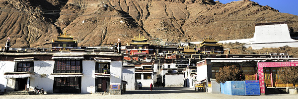
  Tashilhunpo Monastery, founded in 1447 by Gendun Drup, the First Dalai Lama, is a historic and culturally important monastery next to Shigatse, the second-largest city in Tibet. It was sacked when the Gurkhas invaded Tibet and captured Shigatse in 1791 before a combined Tibetan and Chinese army drove them back as far as the outskirts of Kathmandu,when they were forced to agree to keep the peace in future, pay tribute every five years, and return what they had looted from Tashilhunpo.


  The monastery is the traditional seat of successive Panchen Lamas, the second highest ranking tulku lineage in the Gelukpa tradition. The "Tashi" or Panchen Lama had temporal power over three small districts, though not over the town of Shigatse itself, which was administered by a dzongpön (prefect) appointed from Lhasa.
  Located on a hill in the center of the city, the full name in Tibetan of the monastery means: "all fortune and happiness gathered here" or "heap of glory".
  Tashi Lhunpo Monastery is a nonprofit charitable organization which imparts various aspects of the Buddhist religion while maintaining a school of modern education. In recent years it has matured into a reputable full-fledged monastery, performing a vital role in the preservation of Buddhism. One aspect of a monastery is the parental-like responsibility of looking after the physical, mental and spiritual well-being of all the monks, throughout their lives. The modern school is at the budding stage and faces enormous daily hurdles. Yet, there is faith in divine help as the school moves along.

2013年3月24日星期日

Drepung is the largest of all Tibetan monasteries

Drepung Monastery , located at the foot of Mount Gephel, is one of the "great three" Gelukpa university monasteries of Tibet. The other two are Ganden and Sera. Drepung is the largest of all Tibetan monasteries and is located on the Gambo Utse mountain, five kilometers from the western suburb of Lhasa.

514 

Freddie Spencer Chapman reported, after his 1936-37 trip to Tibet, that Drepung was at that time the largest monastery in the world, and housed 7,700 monks, "but sometimes as many as 10,000 monks."

Since the 1950s, Drepung Monastery, along with its peers Ganden and Sera, have lost much of their independence and spiritual credibility in the eyes of Tibetans since they operate under the close watch of the Chinese security services. All three were reestablished in exile in the 1950s in Karnataka state in south India. Drepung and Ganden are in Mundgod and Sera is in Bylakuppe.

513

The organizational hierarchy of the monastery is rather complex. The main branches of the organization consist of Coqen, Zhacang, Kamcun, and Myicun. Coqen is in the highest position, to which Zhacang belongs, and Kamcun is under the jurisdiction of Zhacang, with the Myicun as its subordinate. Monks belonging to respective Zhacangs cannot interblend with each other.

The ground of the monastery is organized on the caves and temples for Jamyang Qoigyi, together with two magnificent white pagodas. The buildings here then are centered on these pagodas, The major buildings are Ganden Potrang, Coqen Hall, the four Zhacangs (or Tantric colleges), and Kamcuns.

2013年3月12日星期二

Gangrenboqi Mountain is the most famous holy mountain in Tibet

  Gangrenboqi Mountain is the most famous holy mountain in Tibet, which is reputed as the center of the world by Tibetan Buddhism, Hinduism, Jainism and Bon. With the elevation of 6,638 meters above sea level, Gangrenboqi Mountain is the main peak of Mt. Gangdise. Hiking abound Gangrenboqi Mountain takes about 3 days, starting from Dajin, passing by Qugu Temple and Zherepu Temple and coming back to the starting point. On the way, there are surpassingly beautiful peaks, magnificent Gangrenboqi Mountain immediately ahead and religious pilgrims, enjoying breathtaking scenery and experiencing local customs and sacred culture. On the elevation of over 4,700 meters, it’s a great risk and ordeal for hikers. Thus, you’d better prepare suitable warm clothes and enough high-calorie food.

491 
  Tibet is regarded as the roof of the world, and full of charm and mystery. His charm lies not only in the original natural and exotic strange natural beauty, but also because of his enigmatic history and the god like religious cultural.
  To some extent, if you understand the religion of Tibet, means you have learned about the history of Tibet. Gangrenboqi is the main peak of the Gangdese Mountains Trans Tibet.

490
  Every year, pilgrims from India, Nepal, Bhutan and Mainland of China are flooded there. Circling around the mountain is the most common way used by pilgrims from different places. Pilgrimage to the mountain is a long-cherished wish in the life of a Buddhist or Hindu or Indian Jains. But after all I still have the chance to see the Gangrenboqi, the ideal kingdom of heaven for the prayers.

2013年3月3日星期日

Lake Manasarovar is the most sacred lake for Tibetans

  Lake Manasarovar (玛旁雍措 Mapangyongcuo /mah-pung-yong-tswaw) is the highest freshwater lake in the world at an altitude of 4,588 m (15,052 ft). In Tibetan, "Manasarovar" means "the Immortal Lake of Jade". It is the most sacred lake for Tibetans, and pilgrims deem it a most blessed thing to circle around and bathe in the lake. Lake Manasarovar is the source of four great rivers in Asia, namely the Indus, the Sutlej, the Karnali and the Brahmaputra. The circumference of the lake is about 60 kilometers (37 miles), and it takes about 4 or 5 days to circle clockwise around the lake. More information about Lake Manasarovar in China tour.

 496
  Lake Manasarovar is relatively round in shape with the circumference of 88 kilometres (55 mi). Its depth reaches a maximum depth of 90 m (300 ft)[citation needed] and its surface area is 320 square kilometres (120 sq mi). It is connected to nearby Lake Rakshastal by the natural Ganga Chhu channel. Manasarovar is near the source of the Sutlej River which is the easternmost large tributary of the Indus. Nearby are the sources of the Brahmaputra River, the Indus River, and the Karnali River (Ghaghara), an important tributary of the Ganges River.


  Every summer, pilgrims from Tibet, India and Nepal cluster to make circumambulation and bathe in the lake. After that, they will return home and bring some samples of the holy water to family and friends as precious gifts.

2013年2月27日星期三

Gangrenboqi mountain peak known as Ice Mountain

  Gangrenboqi is located on the west of Tibet, the most famous holy mountain in Tibet, which is reputed as the center of the world by Tibetan Buddhism, Hinduism, Jainism and Bon. It earned the reputation of the third highest point in the world because its average elevation is above 4,500 meters. Gangrenboqi Sacred Mountain (elevation of 6,656 meters) was labeled as the first sacred mountain by Tibetan ethnic group. Gangrenboqi Mountain peak is often surrounded by white cloud and is very difficult to get a glimpse of its true looks.

 476

  Gangrenboqi mountain peak known as Ice Mountain. In Burang County Shenghu Mapangyongcuo north. Gangdise Mountains is the main peak, 6,656 meters above sea level. Tibetan word for "God's Mountain", as one of the famous Buddhist holy sites. Mapangyongcuo in the north, snow-covered peak seasons, the walls symmetrical peaks, the highest pyramid Guan Chengyuan, the peak is often above the clouds wind around, the more it mysterious and hard. Hill to a distance of 51 km lap, around eight temples.
  The peak is covered with snow all year round. The vision and mind power is shocking when you ascend the peak. The distribution of the four walls of the peak is in bright symmetry and the round crown resembling pyramid. To date, it is still an unconquered mountain. Gangrenboqi is perceived as the Sacred Mountain by most people.

480
  At the same time, it was perceived as the centre of the world by Hindu, Tibetan Buddhism, Tibet primary religion Ben and Gumaona Buddhism. Gangrenboqi's meaning is “Sacred Mountain” in Tibetan and 'Hindu Lord's Heaven" in Sanskrit. It was also the origin of Ben Buddhism. On the way, there are surpassingly beautiful peaks, magnificent Gangrenboqi Mountain immediately ahead and religious pilgrims, enjoying breathtaking scenery and experiencing local customs and sacred culture. On the elevation of over 4,700 meters, it’s a great risk and ordeal for hikers. Thus, you’d better prepare suitable warm clothes and enough high-calorie food.